Seabed Archaeology
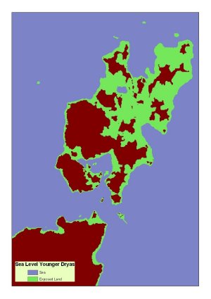
 “GIS reconstruction of the shoreline around Orkney about 10,000 years ago using existing palaeo-shoreline data and bathymetry. This shows the potential extent of submerged land. Reconstruction courtesy of Alistair Dawson (Aberdeen) and Richard Bates (St Andrews)”
Seabed Archaeology: The Rising Tide Project in Orkney
CR Wickham-Jones (University of Aberdeen) and Sue Dawson (University of Dundee)
Introduction
The Rising Tide Project, based at the University of Aberdeen is investigating the potential for submerged archaeological sites to have survived on the seabed around Orkney and reconstructing the changing shape of the islands as rising seas have gradually submerged the land since the end of the last Ice Age. We are keen to work with marine energy developers to ensure careful management of the seabed. In addition, we are looking for sediments from the seabed around Orkney for our analysis. If you are taking samples and might be able to spare some material for us, please get in touch.
Background
Orkney is renowned for its well preserved archaeology which includes the World Heritage Sites of the Heart of Neolithic Orkney. There is, however, an unrecognised side to Orkney archaeology which we are only just staring to research: the submerged landscape of prehistory which existed after the end of the last Ice Age.
Rising seas
During the last Ice Age Orkney was located at the edge of the Scottish ice sheet. This means that the land experienced much less pressure when compared to areas further south, which lay closer to the maximum thickness of ice. This differential crustal rebound since the end of the Ice Age means that relative sea-levels around Orkney have, in fact, been slowly rising so that Orkney has undergone a gradual submergence. The rate of relative sea-level rise is unknown, but it is thought that sea-level may have been as much as -45m below present some 10,000 years ago. The shape of the archipelago has thus changed dramatically. When the ice first retreated Orkney would have formed one large island, and Scapa Flow was a large landlocked bay.
Archaeology
Current evidence suggests that people first settled in Orkney about 10,000 years ago when travelling groups of hunter-fishers came to the islands. It is likely that some archaeological remains from this time, as well as from more recent settlement, have survived on the seabed as sea-levels rose around the islands.
The Work
The project is taking cores from key locations in order to analyse the microfossil content of the sediments. By dating the change from freshwater microfossils to marine microfossils it is possible to get dates for the incursion of sea water into an area. We have also completed a sidescan sonar survey of the Bay of Firth in order to look for anomalies that might be related to submerged archaeology.
Results
So far we have obtained dates that suggest that the seas around Orkney only reached present levels about 4000 years ago. Our cores only relate to the most recent period, however, so we would particularly welcome samples taken from deeper core material. In addition we have identified several promising anomalies in the Bay of Firth and we are hoping to get more information on these in the summer of 2009.
Sponsors:
Historic Scotland
The Crown Estate
Orkney Islands Council
University of Aberdeen
University of Dundee
c.wickham-jones@abdn.ac.uk
S.Dawson@dundee.ac.uk


